Image credit: Nokia
Nokia recently invited a number of US based journalists to see the new HERE Maps data collection car, to see about some of the research that the HERE division is carrying out, and hear about future plans. This has resulted in a number of articles that provide a deeper insight into HERE's data collection and analysis.
In a post on Engadget Myriam Joire explains how Nokia's HERE research teams are using the collected data to bring maps to life, allowing them to gain a better understanding of traffic flow and driver behaviour, which can potentially be used to provide warnings to future drivers:
Another example used CAN bus data collected from taxis in Eindhoven, The Netherlands, to study driver behavior around a sharp bend. By monitoring vehicle position, velocity, acceleration, heading and even windshield-washer settings (to name a few), her team was able to establish recommended speeds and brake points for the curve based on time-of-day and weather conditions. Moreover, the lateral acceleration data revealed the ideal center line for the road. This information could be used to warn drivers approaching the curve too fast at night or in the rain, for example, and would be invaluable for self-driving cars.
While still a few years away this kind of data could be used to provide more intelligent, location specific, alerts to drivers, going far beyond the current traffic and speed restrictions warnings.
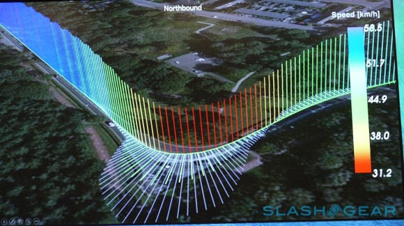
Chris Davies, writing on SlashGear, explains that one of the challenges Nokia is having to solve, because of the large amount of information involved (billions of data points), is how to get a meaningful handle on the data being collected. One way Nokia is trying to understand the data is the creation of visualisation packages:
To harness that information into something meaningful, the HERE Research team developed its own visualization package, complete with a wall-sized display on which to watch it. Speed of each probe is color-coded, overlaid onto different types of map or satellite imagery.
Image credit: SlashGear
These visualisations make it easier to pick out patterns in the data, but the key challenge is deriving useful conclusions from it. Nokia is already working on this process:
One example – which should be visible to Nokia HERE Maps users over the coming months – is using probe data to finesse curved roads. That’s something you struggle to do from pure GPS information, MacFarlane explained, because it’s simply too scattershot to derive the actual topography of the road from. Look instead at data from the movement of vehicles (or the people inside them, and their mobile devices) and you get a far more accurate, far less lossy view of the infrastructure.
The data can also be used to pick out information about traffic flow, potentially helping road planners and city administrators make smarter decisions. One example, cited in the SlashGear report, is how data about average breaking points can be used to plan warning sign placement.
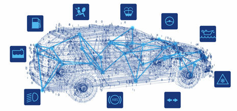
The broad scope of the data is going to key to unlocking the full potential if Advanced Driver Assistance Systems (ADAS), regardless of whether a human or AI is behind the wheel. Initially humans will be the focus with warnings flashed on to the dashboard, but naturally it is self driving cars that capture the imagination.
Kevin Fitchard, writing on GigaOm, explains that Nokia is looking at launching a connected car platform in the future, moving beyond its current mapping and traffic products:
What kind of connected car services is Nokia planning beyond mapping? Halbherr wouldn’t talk specifics, saying the company would reveal more of its strategy soon. But he did say that Nokia is thinking far beyond the dashboard with plans to broach autonomous — or driverless — vehicle technologies and explore ways of integrating the car into larger transportation and “smart city” networks.
Halbherr said Nokia envisions cars that can not only direct you or drive you to your destination by the fastest possible route, but also cars that can send you on routes that minimize carbon emissions, that coordinate with the congestion and traffic management systems being developed in large cities and even work in tandem with public transit to more efficiently move people across a densely packed urban landscape. Halbherr said future connected cars can not only tell you the most optimal time to drive, they could also help you avoid driving altogether.
Nokia's official blog, Nokia Conversations, recently published a post on the idea of the connected car, explaining that it is an area that HERE is interested in, and that it is about more than just putting a smartphone in the car. The most obvious aspect of the connected car is presenting the right information, at the right time, in the right way (i.e. in essence, a more intelligent version of the current HERE Drive offering). The underlying idea is to use real-time services (e.g. traffic and parking information) to make journeys more effecient, saving time, fuel costs, and the environment. Nokia believes that, in many cases, these services need to be provided at the global level, but with local intelligence:
It might come as a surprise, but 70 per-cent of the people in urban traffic are simply looking for parking. What people want is to be able to know where they can park, reserve the slot and make a transaction. While there are some parking solutions in few cities, parking is a problem that really needs to be solved on a global or country level to be interesting to car manufacturers.
But as alluded to above, the connected car can be used to extract rich data from the vehicle in real time (e.g. are windscreen wipers on indicating rain fall), giving the potential to provide additional information. Nokia offers the follow example of what benefits this could bring:
Safety is an obvious application. How many of you have been driving, see a downpour, and slam on the brakes and pray for the best? Imagine if we could tell people coming in your direction that they will be affected by the same downpour and that they need to change their behavior. Imagine automotive cloud services that could warn you in advance of a possible dangerous situation.
All four of the articles we've linked to above underline the scale of ambition within Nokia HERE division, something that is still not well understood outside the company. A great deal of investment will be required, and much of the pay-off is still years in the future, but it is quite possible to see the potential for growth, and how the business may become the fundamental "where" platform espoused by Nokia's executives.